
Statistics Canada
www.statcan.gc.ca
Common menu bar links
Place names
Archived Content
Information identified as archived is provided for reference, research or recordkeeping purposes. It is not subject to the Government of Canada Web Standards and has not been altered or updated since it was archived. Please contact us to request a format other than those available.
As a result of the discontinuation of E-STAT, some of the links to the tables available in the publication 98-187-X Introduction to Censuses of Canada, 1665-1871 were broken. The tables can be requested via the Statistics Canada�s Data Liberation Initiative (http://www.statcan.gc.ca/eng/dli/dli). For the convenience of users, the tables are also available on the Queen�s University website: (http://library.queensu.ca/data/census-1665-1871). The website is in English as Queen�s University is not subject to the Official Languages Act.
Alphabetical table of names of localities, with year of first mention in the various Census returns; by provinces
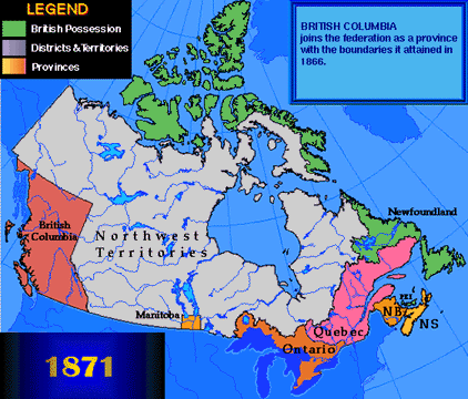
This map was taken from the National
Atlas of Canada.
© 1999. Her Majesty the Queen in Right of Canada with permission of
Natural Resources Canada.
You need to use the free Adobe Reader to view PDF documents. To view (open) these files, simply click on the link. To download (save) them, right-click on the link. Note that if you are using Internet Explorer or AOL, PDF documents sometimes do not open properly. See Troubleshooting PDFs. PDF documents may not be accessible by some devices. For more information, visit the Adobe website or contact us for assistance.