Canada's population estimates: Subprovincial areas, July 1, 2018
Archived Content
Information identified as archived is provided for reference, research or recordkeeping purposes. It is not subject to the Government of Canada Web Standards and has not been altered or updated since it was archived. Please "contact us" to request a format other than those available.
Released: 2019-03-28
Population growth in Canada's urban areas fuelled by permanent and temporary immigration
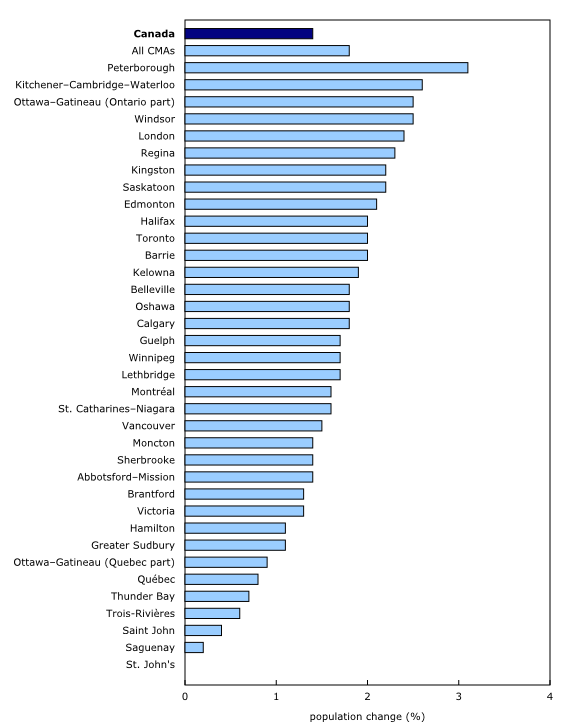
Canada continues to become more urbanized with 26.5 million people living in a census metropolitan area (CMA) on July 1, 2018. Growth in large urban areas (+1.8%) outpaced the rest of the country (+0.6%). Canada's three largest CMAs—Toronto, Montréal and Vancouver—are now home to over one-third of Canadians (35.7%).
Today, Statistics Canada is releasing subprovincial population estimates as of July 1, 2018, including census metropolitan areas, census agglomerations, census divisions and economic regions.
Permanent and temporary immigration is the key driver of population growth in urban Canada. This trend is linked to higher targets for permanent immigration, as defined by Immigration, Refugees and Citizenship Canada. Moreover, various programs stimulate the admission of many temporary workers and foreign students.
Growth in some census metropolitan areas in Ontario outpace growth in the West
Ontario was home to the fastest growing CMAs from July 1, 2017, to July 1, 2018, with Peterborough (+3.1%), Kitchener–Cambridge–Waterloo (+2.6%), Ottawa–Gatineau (Ontario part) and Windsor (+2.5% each), as well as London (+2.4%) leading the way.
Population growth in Alberta's CMAs continues to be affected by the downturn in commodity production that began in 2014 and the resulting rise in unemployment rates. For the third consecutive year, the CMA of Calgary was not among the top 10 for population growth in Canada. Saskatoon and Regina having experienced the greatest growth in 2016/2017, saw a slowing of their growth, while remaining above the population growth of all CMAs.
No CMA experienced a decline in population over the past year.
Urban spread continues to grow
Urban spread continued to grow over the past year in Canada's three largest CMAs. Even though more people left Toronto, Montréal and Vancouver CMAs for surrounding areas, these losses were more than offset by increases in temporary and permanent immigration.
The population outside census metropolitan areas are aging faster
Canada's CMAs are growing faster, but they are aging slower than areas outside CMAs. Over the last decade, the population aged 65 and older rose 3 percentage points to 15.8% in CMAs as of July 1, 2018, compared with a 4.9 percentage point increase to 20.6% in areas outside CMAs.
Despite these trends, some CMAs have older populations than many areas outside CMAs, such as Trois-Rivières (23.2%), Peterborough (22.2%) and St. Catharines–Niagara (22.1%). The CMA of Calgary continues to have the lowest proportion of people aged 65 years and older (11.6%).
Note to readers
On September 27, 2018, Statistics Canada released the first demographic estimates to be based on the 2016 Census population counts. These estimates were for the total population of Canada, the provinces and territories. Today, these estimates are available by subprovincial areas. These new estimates also take into account the 2016 Census net undercoverage and incompletely enumerated Indian reserves. Finally, they include the population change for the period from May 10, 2016, to the date of the estimate. The data starting from July 2006 were also revised.
These estimates are based on the Standard Geographical Classification (SGC) 2016. With the adoption of the SGC 2016, Belleville (Ontario) and Lethbridge (Alberta), which were both a census agglomeration (CA) with the SGC 2011, became census metropolitan areas (CMAs).
The rebasing process of the demographic estimates produced by Statistics Canada is part of the normal procedures carried out after each census in order to ensure the highest possible accuracy of the population estimates. For a given reference date, it is expected that subprovincial population estimates released today differ from those that were published in previous releases, and that were based on the 2011 Census. The size of the differences is similar to what was noted for previous rebasing exercises, such as for the censuses of 2001, 2006 and 2011.
This analysis is based on preliminary data. Since these data will be revised in the coming year, some trends described in this analysis may change as a result of these revisions. Therefore, this analysis should be interpreted with caution.
Annual population estimates by age and sex as of July 1, for the years 2006 to 2018, are available for CMAs, CAs, census divisions and economic regions. See the Tables tab for more information. Annual population estimates by age and sex as of July 1, for the years 2006 to 2018, are also available for census subdivisions on request on a cost-recovery basis.
The annual period of reference is comprised between July 1 of a certain year and July 1 of the following year. Therefore, 2017/2018 refers to the period from July 1, 2017, to July 1, 2018.
A census metropolitan area is formed by one or more adjacent municipalities centred on a population centre (known as the core). A CMA must have a total population of at least 100,000 of which 50,000 or more must live in the core based on adjusted data from the previous Census of Population Program. To be included in the CMA, other adjacent municipalities must have a high degree of integration with the core, as measured by commuting flows derived from data on place of work from the previous Census Program.
The Ottawa–Gatineau CMA is divided into two parts to distinguish its Ontario and Quebec parts.
Products
The publication Annual Demographic Estimates: Subprovincial Areas, July 1, 2018 (91-214-X), is now available.
Contact information
For more information, or to enquire about the concepts, methods or data quality of this release, contact us (toll-free 1-800-263-1136; 514-283-8300; STATCAN.infostats-infostats.STATCAN@canada.ca) or Media Relations (613-951-4636; STATCAN.mediahotline-ligneinfomedias.STATCAN@canada.ca).
- Date modified:


