
Illustrated Glossary
Geographic code
Definition
A geographic code is a numerical identifier assigned to a geographic area. Every kind of geographic area in Canada has its own type of geographic code. For example, the geographic code assigned to a town makes it possible to distinguish that town from any other towns with the same name that are located in a different province. The code is used to identify and access standard geographic areas for the purposes of data storage, retrieval and display.
For more information on geographic code, consult the Dictionary, Census of Population, 2016.
Geographic code tutorial
Most standard geographic areas are commonly known by their names, but these names are not always unique. Geographic codes are numbers that represent a level of geography. When codes that represent lower levels of geography are used in combination with codes that represent higher levels of geography, they provide a way to uniquely identify each geographic unit in Canada.
For example, the name 'Windsor' identifies three different census subdivisions (CSDs) [municipalities] in Canada. To uniquely identify each of these Windsor CSDs in Canada, the two-digit province/territory (PR) code and the two-digit census division (CD) code must precede the three-digit census subdivision (CSD) code:
| PR-CD-CSD code | Province (PR) name | Census division (CD) name | Census subdivision (CSD) name |
|---|---|---|---|
| 12 08 002 | Nova Scotia | Hants | Windsor |
| 24 42 088 | Quebec | Le Val-Saint-François | Windsor |
| 35 37 039 | Ontario | Essex | Windsor |
In another example, we see a few different types of geographic units in Ontario share the name 'Toronto.' All of these overlap in the same general area: census subdivision (CSD), census division (CD), census metropolitan area (CMA), population centre (POPCTR) and economic region (ER). The geographic coding structure for each corresponding area is what differentiates one area from the next.
For each level of geography, the unique code consists of a combination of the geographic code for that specific level as well as the code for higher levels of geography. For example, at the CD level, the unique geographic code (3520) combines the PR code (35) and the CD code (20). Similarly, the unique CSD code (3520005) combines the PR code (35), the CD code (20) and the CSD code (005). The census metropolitan area, on the other hand, is comprised of a combination of the PR code (35) and the CMA code (535). These geographic codes only become unique identifiers when they are grouped in this manner.
Geographic areas named 'Toronto' (Ontario)
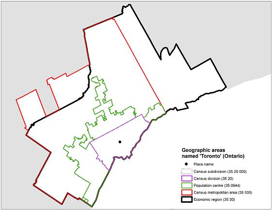
Description of map
The above map shows the six overlapping geographic areas in Ontario named 'Toronto' and their associated geographic codes. These include the census metropolitan area, economic region, population centre, census division, census subdivision and place name.
Source: Statistics Canada, 2016 Census of Population.
- Date modified: