
Chart 3.28
Natural and semi-natural land lost to settled area, by selected land class, Moncton census metropolitan area-ecosystem (CMA-E), 1971 to 2011

Archived Content
Information identified as archived is provided for reference, research or recordkeeping purposes. It is not subject to the Government of Canada Web Standards and has not been altered or updated since it was archived. Please "contact us" to request a format other than those available.
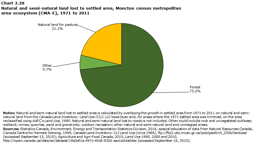
Data table for Chart 3.28
| Forest | Natural land for pasture | Other | Forest | Natural land for pasture | Other | |
|---|---|---|---|---|---|---|
| square kilometres | percent of total | |||||
| Moncton | 62.5 | 18.1 | 4.8 | 73.2 | 21.2 | 5.7 |
|
Notes: Natural and semi-natural land lost to settled area is calculated by overlaying the growth in settled area from 1971 to 2011 on natural and semi-natural land from the Canada Land Inventory: Land Use (CLI: LU) base layer and, for areas where the 1971 settled area was trimmed, on the area reclassified using AAFC's Land Use, 1990. Natural and semi-natural land lost to roads is not included. Other could include rock and unvegetated surfaces; wetland; mines, quarries, sand and gravel pits; outdoor recreation; other natural and semi-natural land and unmapped areas. Sources: Statistics Canada, Environment, Energy and Transportation Statistics Division, 2016, special tabulation of data from Natural Resources Canada, Canada Centre for Remote Sensing, 1999, Canada Land Inventory: CLI Land Use (circa 1966), ftp://ftp2.cits.rncan.gc.ca/pub/geott/cli_250k/landuse/ (accessed September 15, 2015); Agriculture and Agri-Food Canada, 2015, Land Use 1990, 2000 and 2010, http://open.canada.ca/data/en/dataset/18e3ef1a-497c-40c6-8326-aac1a34a0dec (accessed September 16, 2015). |
||||||
- Date modified: