
Community Snapshot Toolkit

Archived Content
Information identified as archived is provided for reference, research or recordkeeping purposes. It is not subject to the Government of Canada Web Standards and has not been altered or updated since it was archived. Please "contact us" to request a format other than those available.
Release date: November 16, 2021
The Community Snapshot Toolkit is designed to allow users to create data-based images. This webpage is for reference purposes only, and we encourage users to access the following PDF version in order to create, convert and publish their community snapshot.
Create Your Community Snapshot
Feature your community using census data.
Introduction
This toolkit provides all the information you need to get the most out of census data about your community. Communities all over Canada use population counts, educational information, and labour force data from the census to make timely and informed decisions. Use this toolkit to help create individualized infographics for your community.
Read the terms of use, and then follow the easy steps to create one or both of the following visualizations:
Example of a map template—for reference purposes only
The map template
Description—Map template
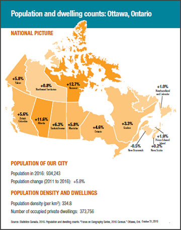
The title of the infographic is "Population and dwelling counts: Ottawa, Ontario."
The infographic includes three components: "National picture," "Population of our city," and "Population density and dwellings."
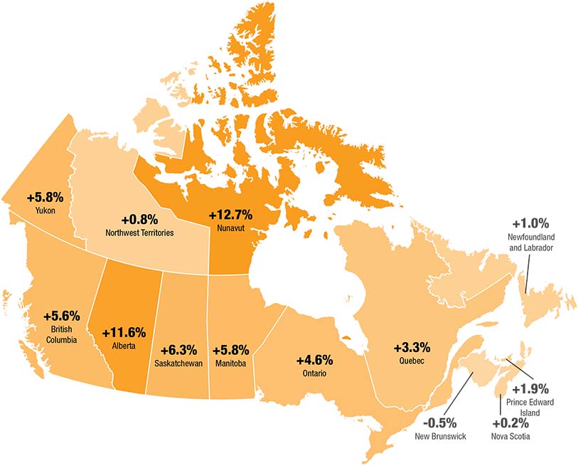
National picture: This is a map of Canada by province and territory showing the percentage changes in population from 2011 to 2016.
Population count went up 1.0% in Newfoundland and Labrador, up 1.9% in Prince Edward Island, up 0.2% in Nova Scotia, down 0.5% in New Brunswick, up 3.3% in Quebec, up 4.6% in Ontario, up 5.8% in Manitoba, up 6.3% in Saskatchewan, up 11.6% in Alberta, up 5.6% in British Columbia, up 5.8% in Yukon, up 0.8% in Northwest Territories, and up 12.7% in Nunavut.
Population of our city: the population in 2016 was 934,243, and the population change from 2011 to 2016 was +5.8%.
Population density and dwellings: population density per km2 was 334.8, and the number of occupied dwellings was 373,756.
Source: Statistics Canada. 2016. Population and dwelling counts. "Focus on Geography Series, 2016 Census." Ottawa, Ont. October 31, 2019.
This template shows your community's population and dwelling counts, and how your community compares with the rest of Canada.
Example of a table template—for reference purposes only
The table template
Description—Table template
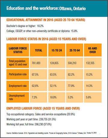
The title of the infographic is "Education and the workforce: Ottawa, Ontario."
The infographic includes three components: "educational attainment in 2016 (aged 25 to 64 years)," "labour force status in 2016 (aged 15 years and over)," and "employed labour force (aged 15 years and over)."
Educational attainment in 2016 (aged 25 to 64 years): The percentage of people aged 25 to 64 years who obtained a bachelor's degree or higher was 18.2%. The percentage of people aged 25 to 64 years who obtained a College, CEGEP, or other non-university certificate or diploma was 15.8%.
| Labour force | Total | 15 to 24 | 25 to 64 | 65 and over |
|---|---|---|---|---|
| Total population aged 15 and over | 761,420 | 124,855 | 504,210 | 132,355 |
| Participation rate | 67.5% | 63.5% | 82.2% | 15.2% |
| Employment rate | 62.6% | 52.1% | 77.9% | 14.3% |
| Unemployment rate | 7.2% | 18.0% | 5.2% | 5.6% |
Employed labour force (aged 15 years and over): The top occupational category was sales and service occupations (20.9%). The number of people working part year or part time was 239,755 (31.5%). The number of people working full year, full time was 286,230 (37.6%).
Source: Statistics Canada. 2016. Population and dwelling counts. "Focus on Geography Series, 2016 Census." Ottawa, Ont. October 31, 2019.
This template shows your community's educational attainment and labour force data.
Steps to build the map template
- Visit the Focus on Geography Series web page. Search for your community by entering its name into the search bar. You will be redirected to your community's page.
- Find all the data you need on your community's page, and fill in the blanks on the template by following the instructions included within each field.
- Select Finish at the bottom of page 4 of this toolkit. Now you can save your map template.
Note: You will not be able to make changes to your snapshot after selecting Finish. - Print it or share it! To post your community snapshot on social media or your local bulletin board, save it as an image. Go to www.pdf2jpg.net, upload the file, and convert it to a jpg.
Population and dwelling counts: [Enter the name of your community or city and the name of your province or territory. (e.g., Ottawa, Ontario)]
Description—National picture of population and dwelling counts
| Province or territory | Population change (2011 to 2016) |
|---|---|
| Yukon | +5.8% |
| Northwest Territories | +0.8% |
| Nunavut | +12.7% |
| British Columbia | +5.6% |
| Alberta | +11.6% |
| Saskatchewan | +6.3% |
| Manitoba | +5.8% |
| Ontario | +4.6% |
| Quebec | +3.3% |
| New Brunswick | -0.5% |
| Nova Scotia | +0.2% |
| Prince Edward Island | +1.9% |
| Newfoundland and Labrador | +1.0% |
Population of our [Enter the category of your location (e.g., town, city, municipality).]
Population in 2016: [Insert population count (e.g., 934,243).]
Population change (2011 to 2016): [Insert percentage change (e.g.,+5.8%).]
Population density and dwellings
Population density (per km2): [Insert population density (e.g., 334.8).]
Number of occupied private dwellings: [Insert number of occupied private dwellings (e.g., 373,756).]
Steps to build the table template
- Visit the Focus on Geography Series web page. Search for your community by entering its name into the search bar. You will be redirected to your community's page.
- Find all the data you need by selecting Education or Labour from the dropdown menu at the top of your community's page. Fill in the blanks on the template by following the instructions included within each field.
- Select Finish at the bottom of page 6 of this toolkit. Now you can save your table template.
Note: You will not be able to make changes to your snapshot after selecting Finish. - Print it or share it! To post your community snapshot on social media or your local bulletin board, save it as an image. Go to www.pdf2jpg.net, upload the file, and convert it to a jpg.
Education and the workforce: [Enter the name of your community or city and the name of your province or territory. (e.g., Ottawa, Ontario)]
Educational attainment in 2016 (aged 25 to 64 years)
Bachelor's degree or higher: [Insert percentage (e.g., 18.2%).]
College, CEGEP, or other non-university certificate or diploma: [Insert percentage (e.g., 15.8%).]
Labour force status in 2016 (aged 15 years and over)
| Total | 15 to 24 | 25 to 64 | 65 and over |
|---|---|---|---|
| Total population aged 15 and over [Insert number.] | |||
| Participation rate [Insert percentage.] | |||
| Employment rate [Insert percentage.] | |||
| Unemployment rate [Insert percentage.] |
Employed Labour force (aged 15 years and over)
Top occupational category: [Insert name of top occupation and percentage (e.g., Sales and service occupations (20.9%)).]
Working part year or part time: [Insert number and percentage (e.g., 239,755 (31.5%)).]
Working full year, full time: [Insert number and percentage (e.g., 286,230 (37.6%)).]
Terms of use
Official languages
All materials are available in both English and French. We encourage you to publish and distribute materials in both official languages.
Modifications of materials
Alterations may be made to this community snapshot toolkit templates to better fit your needs. However, the Government of Canada wordmark or identifiers cannot be used.
Statistics Canada is providing this toolkit for creating community snapshots with census data. However, the end result is not a Statistics Canada product.
Census data product — Focus on Geography Series
The online data product that you are encouraged to use is the Focus on Geography Series. It will help you find the necessary data to complete your community snapshot. It presents data highlights for each of the major data topics from the 2016 Census, focusing on your selected geographic area. These data highlights are presented through text, tables and figures. A map image of the geographic area is also included.
Other census data products are also available on the Statistics Canada website, including the Census Profile.
Statistics Canada encourages the downloading and reuse of its data, but also emphasizes the importance of properly citing the original source.
Sourcing census data
References are important when you are using the data or ideas of others in your written work; references credit your sources and enable your readers to find those sources. Authors and researchers must give full credit for any Statistics Canada data, analysis or other content material used or referred to in their community snapshot. Please add the date the data was accessed to the source field on the bottom of pages 4 and 6. More details can be found on the How to Cite Statistics Canada Products web page.
Census dictionary
The Census of Population Dictionary is an online reference document that contains detailed definitions of Census of Population concepts. By referring to this dictionary, both beginner and intermediate data users will gain a better understanding of the data.
The Census of Population Dictionary also contains information regarding census geographic levels, along with the census geographic structure.
In the context of the census geographic structure, the term "community" is associated with census subdivision.
Accessing links
When you open a link, if a security pop-up asks you to allow or block the links, select "allow."
If you are unable to open the hyperlinks in this toolkit, a list of all the links is provided on page 8.
For more information on Statistics Canada's terms of use, please email us.
Links
- Focus on Geography Series
- Census Profile
- Census data products
- Census of Population Dictionary
- Census geographic structure
- How to Cite Statistics Canada Products
- How to convert a PDF to a JPG
Inquiries about this product? Contact us at: statcan.censusmarketingandengagement-marketingetengagementdurecensement.statcan@canada.ca
- Date modified: