
Dissemination Geographies Relationship File, Reference Guide, Census year 2021
Skip to text
Text begins
This reference guide is intended for users of the 2021 Dissemination Geographies Relationship File (DGRF). This guide provides an overview of the file, the general methodology used to create it, and important technical information.
1. About this guide
This reference guide is intended for users of the 2021 DGRF. The Technical specifications section includes the record layout.
This data product is provided 'as-is,' and Statistics Canada makes no warranty, either expressed or implied, including but not limited to, warranties of merchantability and fitness for a particular purpose. In no event will Statistics Canada be liable for any direct, special, indirect, consequential or other damages, however caused.
2. Overview
The 2021 DGRF contains information at the dissemination block (DB) level, based on 2021 Census standard geographic areas, along with higher level Dissemination Geographies Unique Identifiers (DGUIDs).
The DGRF released on November 17th, 2021 includes the relationships between the DB and higher geographic levels that are not population and dwelling counts dependent. A final version of the 2021 DGRF, including all levels of standard geographies, will be released on February 9th, 2022.
3. About this product
Purpose of the product
The 2021 DGRF is a dataset at the DB level that contains the complete set of 2021 Census geographic areas. The purpose of this product is for it to be used with the 2021 Census Boundary Files to link geographic areas with higher geographic levels using the DGUIDs.
Definitions and concepts
Geographic terms and concepts are briefly defined in the Dictionary, Census of Population, 2021.
Relationships – spatial vs tabular
Relationships between lower and higher geography levels can be achieved either spatially or in a tabular fashion. Spatial relationships consist in superimposing layers of geographic data that cover the same area in order to study the relationship between them. Tabular relationships consist in establishing a connection between two layers using a key common to both.
In the context of the 2021 Census Boundary Files, all the different levels of geographies have been integrated vertically, therefore spatial relationships are possible using GIS technology, either for analysis or mapping, as shown in the image below that presents an example of a spatial overlay between a dissemination area (DA), a census subdivision (CSD) and a census division (CD).
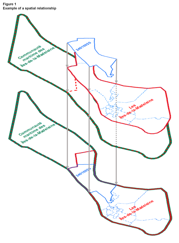
Description of Figure 1
This figure presents a spatial relationship, where the DA boundary 24010020 (in blue), the CSD boundary of Les Îles-de-la-Madeleine (in red) and the CD boundary of la Communauté maritime des Îles-de-la-Madeleine (in green) are perfectly superimposed.
Users can obtain similar results as above but in tabular fashion using the attribute tables of the 2021 Census Boundary Files, along with the DGRF. Each boundary file level includes a DGUID that can be used to link to the DGRF. For example, the DGUID from the “DA Boundary Files” can be linked to the DGRF using the DADGUID_ADIDUGD attribute. Additional linkages to the “CSD and CD boundary files” will then be possible using the CSDDGUID_SDRIDUGD and the CDDGUID_DRIDUGD attributes in the DGRF along with the corresponding DGUID in the “CSD and CD Boundary Files”.
The image below presents an example of linking a given DA to its corresponding CSD and CD using the DGRF:

Description of Figure 2
This figure presents a tabular relationship, where the DGUID of the DA 24010020 in the “DA Boundary Files” is linked to the DADGUID_ADIDUGD in the DGRF, and the corresponding CSDDGUID_SDRIDUGD and CDDGUID_DRIDUGD in the DGRF are linked respectively to the DGUIDs in the “CSD and CD Boundary Files”. The results table presents the content of all three (3) boundary files joined in a single record.
Content
The 2021 DGRF contains all the DGUIDs for the 2021 Census standard geographic areas. It is a DB level dataset that also includes information for the following:
Release 1: November 17th, 2021
- Provinces and territories (PRs)
- Census divisions (CDs)
- Federal electoral districts (FEDs) (2013 Representation Order)
- Census subdivisions (CSDs)
- Economic regions (ERs)
- Census agricultural regions (CARs)
- Census consolidated subdivisions (CCSs)
- Dissemination areas (DAs)
- Aggregate dissemination areas (ADAs)
Release 2: February 9th, 2022
- All of release 1
- Designated places (DPLs)
- Census metropolitan areas and census agglomerations (CMA/CAs)
- Census tracts (CTs)
- Population centres (POPCTRs)
General methodology
The National Geographic Database (NGD) is a joint Statistics Canada - Elections Canada initiative to develop and maintain a spatial database which serves the needs of both organizations. The focus of the NGD is the continual improvement of quality and currency of spatial coverage using updates from provinces, territories and local sources.
The native files used for the creation of the 2021 DGRF reside on Statistics Canada's Spatial Data Infrastructure (SDI) which was derived directly from data stored in the NGD environment. In creating the 2021 DGRF, all DBs were extracted from the SDI along with DGUIDs for the higher level standard geographic areas in which DBs are located.
Limitations
Not applicable
Comparison to other products or versions
The 2021 DGRF is compatible with the suite of 2021 Census geography products. There is no previous version of the DGRF.
Use with other products
The 2021 Census standard geographic areas in the 2021 DGRF can be linked to other 2021 Census geography products, such as the 2021 Census Boundary Files, using the DGUIDs.
Reference date
The geographic reference date is a date determined by Statistics Canada to finalize the geographic framework for which 2021 Census statistical data are collected, tabulated and reported. The reference date for 2021 Census standard geographic areas is January 1, 2021.
4. Technical specifications
Record layout and data descriptions
| Attribute name | Data type | Description | Release |
|---|---|---|---|
| PRDGUID_PRIDUGD | Character (21) | Dissemination Geography Unique Identifier for 2021 Province and Territory.Table 4.1 Note 1 | November 2021 and February 2022 |
| CDDGUID_DRIDUGD | Character (21) | Dissemination Geography Unique Identifier for 2021 Census Division.Table 4.1 Note 1 | November 2021 and February 2022 |
| FEDDGUID_CEFIDUGD | Character (21) | Dissemination Geography Unique Identifier for 2013 Federal Electoral District.Table 4.1 Note 1 | November 2021 and February 2022 |
| CSDDGUID_SDRIDUGD | Character (21) | Dissemination Geography Unique Identifier for 2021 Census Subdivision.Table 4.1 Note 1 | November 2021 and February 2022 |
| ERDGUID_REIDUGD | Character (21) | Dissemination Geography Unique Identifier for 2021 Economic Region.Table 4.1 Note 1 | November 2021 and February 2022 |
| CARDGUID_RARIDUGD | Character (21) | Dissemination Geography Unique Identifier for 2021 Census Agricultural Region.Table 4.1 Note 1 | November 2021 and February 2022 |
| CCSDGUID_SRUIDUGD | Character (21) | Dissemination Geography Unique Identifier for 2021 Census Consolidated Subdivision.Table 4.1 Note 1 | November 2021 and February 2022 |
| DADGUID_ADIDUGD | Character (21) | Dissemination Geography Unique Identifier for 2021 Dissemination Area.Table 4.1 Note 1 | November 2021 and February 2022 |
| DBDGUID_IDIDUGD | Character (21) | Dissemination Geography Unique Identifier for 2021 Dissemination Block.Table 4.1 Note 1 | November 2021 and February 2022 |
| ADADGUID_ADAIDUGD | Character (21) | Dissemination Geography Unique Identifier for 2021 Aggregate Dissemination Area.Table 4.1 Note 1 | November 2021 and February 2022 |
| DPLDGUID_LDIDUGD | Character (21) | Dissemination Geography Unique Identifier for 2021 Designated Place.Table 4.1 Note 1 | February 2022 |
| CMAPDGUID_RMRPIDUGD | Character (21) | Dissemination Geography Unique Identifier for 2021 Census Metropolitan Area or Census Agglomeration Part.Table 4.1 Note 1 | February 2022 |
| CMADGUID_RMRIDUGD | Character (21) | Dissemination Geography Unique Identifier for 2021 Census Metropolitan Area or Census Agglomeration.Table 4.1 Note 1 | February 2022 |
| CTDGUID_SRIDUGD | Character (21) | Dissemination Geography Unique Identifier for 2021 Census Tract.Table 4.1 Note 1 | February 2022 |
| POPCTRPDGUID_CTRPOPPIDUGD | Character (21) | Dissemination Geography Unique Identifier for 2021 Population Center Part.Table 4.1 Note 1 | February 2022 |
| POPCTRDGUID_CTRPOPIDUGD | Character (21) | Dissemination Geography Unique Identifier for 2021 Population Center.Table 4.1 Note 1 | February 2022 |
|
|||
Attribute domain values
Not applicable
File specifications
The 2021 DGRF’s size is approximately 100 MB in comma separated value format (.csv).
Software formats
This reference guide does not provide details on specific software packages that are available for use in comma separated value format (.csv). Users are advised to contact the appropriate software vendor for information.
File extension and accented character information
Not applicable
Geographic representation
Not applicable
File naming convention
The 2021 DGRF follows a standard naming convention. The file name includes: Census year, catalogue number, file format.
The 2021 DGRF, in comma separated value (.csv) format, is named as follows: 2021_98260004.csv
5. Data quality
Data quality elements provide information on the fitness-for-use of a dataset by describing why, when, how the data are created, and how accurate the data are. The quality elements include an overview reporting on the lineage, positional accuracy, attribute accuracy, logical consistency and completeness. This information is provided to users for all geographic data products disseminated for the census.
Lineage
Lineage describes the history of the data, including descriptions of the source material from which the data were derived and the methods of derivation. It also contains the dates of the source material and all transformations involved in producing the file.
All data in the DGRF were originally extracted from Statistics Canada's SDI.
Positional accuracy
Not applicable
Attribute accuracy
Attribute accuracy refers to the accuracy of the quantitative and qualitative information attached to each feature.
The DGUIDs contained within the 2021 DGRF, along with the relationships between all standard geographic areas, were verified against Statistics Canada's SDI. The Figure 1.1, “Hierarchy of standard geographic areas for dissemination, 2021 Census,” illustrates the relationships between all standard geographic areas.
Logical consistency
Logical consistency describes the fidelity of relationships encoded in the data structure of the digital spatial data.
Internal consistency
Consistency between the data at the various geographic levels was verified. Verification procedures included checks to ensure all the 2021 dissemination blocks are included in the DGRF. All geographic areas in the DGRF have also been verified to ensure that they have a valid DGUID for the 2021 Census.
Consistency with other products
The DGUIDs used in the 2021 DGRF are the same as those used in other geography products and represent the same geographic areas.
Completeness
Completeness refers to the degree to which geographic features, their attributes and their relationships are included or omitted in a dataset. It also includes information on selection criteria, definitions used and other relevant mapping rules.
The 2021 DGRF contains a DGUID for each geographic area. It also contains the appropriate number of geographic areas for each standard geographic level. Refer to Table 1.1, “Geographic areas by province and territory, 2021 Census,” from the Dictionary, Census of Population, 2021. These numbers were verified within the 2021 DGRF.
- Date modified: