
Correspondence Files, Reference Guide, Census year 2021
This reference guide is intended for users of the 2021 Correspondence Files. This guide provides an overview of the files, the general methodology used to create them, and important technical information.
What's new?
- The 2021 Correspondence Files are available only in comma-separated value (.csv) format.
- The Dissemination Geography Unique Identifiers (DGUIDs) have been added to all files.
1. About this guide
This reference guide is intended for users of the 2021 Correspondence Files. The Technical specifications section includes record layouts.
This data product is provided 'as-is,' and Statistics Canada makes no warranty, either express or implied, including but not limited to, warranties of merchantability and fitness for a particular purpose. In no event will Statistics Canada be liable for any direct, special, indirect, consequential or other damages, however caused.
2. Overview
There are three 2021 Correspondence Files:
- The “Dissemination Area Correspondence File” describes the relationship between the 2021 dissemination area (DA) and the 2016 DA.
- The “Dissemination Block Correspondence File” describes the relationship between the 2021 dissemination block (DB) and the 2016 DB.
- The “Dissemination Area and Land Area Correspondence File” describes the percentage of the 2021 DA's land area contained within the boundaries of the 2016 DA.
3. About this product
Purpose of the product
The 2021 Correspondence Files provide users with tabular data that describe the correspondence between two vintages of geographic areas.
Definitions and concepts
Relationship flags
A relationship flag indicates the type of relationship that exists between sets of data, in the case of the correspondence files, the relationships between two census years.
In the correspondence files, the relationship flags are one-to-one (1:1), one-to-many (1:n), many-to-one (n:1) or many-to-many (n:n). A one-to-one relationship indicates that no change has taken place. A one-to-many relationship indicates that arcs have been added to the base and one 2016 block has become multiple 2021 blocks. An example scenario would be if a new road has been built.

Description for Figure 3.1
Example of a one-to-many relationship with a red rectangle representing a 2016 area with two black rectangles on top representing 2021 areas.
A many-to-one relationship indicates that arcs have been removed and multiple 2016 blocks have become one 2021 block.
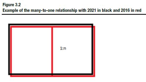
Description for Figure 3.2
Example of a many-to-one relationship with two red rectangles representing the 2016 areas with a black rectangle on top representing the 2021 area.Finally, a many-to-many relationship indicates that multiple new 2021 blocks have been created from parts of numerous 2016 blocks, an example would be three 2016 blocks that have become two 2021 blocks.
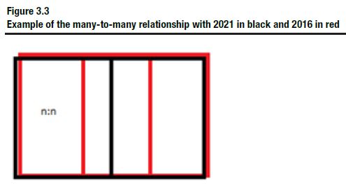
Description for Figure 3.3
Example of a many-to-many relationship with three red rectangles representing the 2016 areas with two black rectangles on top representing the 2021 areas.
Other geographic terms and concepts are defined in the Dictionary, Census of Population, 2021.
Content
Dissemination Area Correspondence File
The “Dissemination Area Correspondence File” describes the relationship between the 2021 and the 2016 DAs. The file contains the UID and DGUID of the 2021 DAs, the 2016 DAs and the 2021 DBs, as well as a relationship flag.
The following series of tables provide statistical information explaining the changes to the DAs between the 2016 and 2021 censuses.
The following table contains detailed counts for all 2021 DAs.
| Relationship type | Count | Percent |
|---|---|---|
| one 2021 dissemination area = one 2016 dissemination area | 54,185 | 93.53 |
| one 2021 dissemination area = many 2016 dissemination areas | 16 | 0.03 |
| many 2021 dissemination areas = one 2016 dissemination area | 1,443 | 2.49 |
| many 2021 dissemination areas = many 2016 dissemination areas | 2,292 | 3.96 |
| Note: Totals may not add to 100 due to rounding. | ||
The following table contains detailed counts for 2021 DAs inside census tracts (CTs).
| Relationship type | Count | Percent |
|---|---|---|
| one 2021 dissemination area = one 2016 dissemination area | 37,235 | 93.72 |
| one 2021 dissemination area = many 2016 dissemination areas | 3 | 0.01 |
| many 2021 dissemination areas = one 2016 dissemination area | 1,249 | 3.14 |
| many 2021 dissemination areas = many 2016 dissemination areas | 1,242 | 3.13 |
| Note: Totals may not add to 100 due to rounding. | ||
The following table contains detailed counts for 2021 DAs outside CTs.
| Relationship type | Count | Percent |
|---|---|---|
| one 2021 dissemination area = one 2016 dissemination area | 16,950 | 93.10 |
| one 2021 dissemination area = many 2016 dissemination areas | 13 | 0.07 |
| many 2021 dissemination areas = one 2016 dissemination area | 194 | 1.07 |
| many 2021 dissemination areas = many 2016 dissemination areas | 1,050 | 5.77 |
| Note: Totals may not add to 100 due to rounding. | ||
Dissemination Block Correspondence File
The “Dissemination Block Correspondence File” describes the relationship between the 2021 and the 2016 DBs. The file contains the UID and DGUID of the 2021 DBs and the 2016 DBs, as well as a relationship flag.
The following table contains detailed counts for all 2021 DBs.
| Relationship type | Count | Percent |
|---|---|---|
| one 2021 dissemination block = one 2016 dissemination block | 440,565 | 84.35 |
| one 2021 dissemination block = many 2016 dissemination blocks | 24,910 | 4.77 |
| many 2021 dissemination blocks = one 2016 dissemination block | 32,241 | 6.17 |
| many 2021 dissemination blocks = many 2016 dissemination blocks | 24,590 | 4.71 |
| Note: Totals may not add to 100 due to rounding. | ||
Dissemination Area and Land Area Correspondence File
The “Dissemination Area and Land Area Correspondence File” describes the relationship between the 2021 and the 2016 DAs. The file contains the UID and DGUID of the 2021 DAs and the 2016 DAs, a relationship flag and percentage of land area. The percentage of land area attribute describes the percentage of the 2021 DA land area within the boundaries of the 2016 DA.
General methodology
The National Geographic Database (NGD) is a joint Statistics Canada-Elections Canada initiative to develop and maintain a spatial database which serves the needs of both organizations. The focus of the NGD is the continual improvement of quality and currency of spatial coverage using updates from provinces, territories and local sources.
The native files used for the creation of the 2021 Correspondence Files reside on Statistics Canada's Spatial Data Infrastructure (SDI) and were derived directly from data stored in the NGD environment. 2016 and 2021 attribute information, such as UIDs and land area, was retrieved from SDI and percentages were calculated using the lowest level of geography available.
Limitations
Not applicable
Comparisons to other products or versions
Not applicable
Use with other products
The 2021 Correspondence Files can be used to link 2021 data with the corresponding 2016 areas. The UIDs can be used as a link to previous census geography products, such as GeoSuite and the Geographic Attribute File, to retrieve higher geographic level data, census population and dwelling counts or other attributes included in these products.
Reference date
The geographic reference date is a date determined by Statistics Canada to finalize the geographic framework for which census data are collected, tabulated and reported. The reference date for the 2021 Correspondence Files is January 1, 2021.
4. Technical specifications
Record layouts and data descriptions
The following tables identify and briefly describe the selected attributes comprising the content of the 2021 Correspondence Files.
| Attribute name | Data type | Description |
|---|---|---|
| DAUID2021_ADIDU2021 | Character (8) | Uniquely identifies a dissemination area (composed of the two-digit province/territory code, the two-digit census division code, and the four-digit dissemination area code), 2021 Census. |
| DAUID2016_ADIDU2016 | Character (8) | Uniquely identifies a dissemination area (composed of the two-digit province/territory code, the two-digit census division code, and the four-digit dissemination area code), 2016 Census. |
| DBUID2021_IDIDU2021 | Character (11) | Uniquely identifies a dissemination block (composed of the two-digit province/territory code, the two-digit census division code, the four-digit dissemination area code, and the three-digit dissemination block code), 2021 Census. |
| DARELFLAG_ADINDREL | Character (1) | Relationship flag indicating if the 2021 dissemination area is equal to the 2016 dissemination area or has a one-to-many relationship, a many-to-one relationship or a many-to-many relationship. |
| 1 – one 2021 dissemination area was one 2016 dissemination area | ||
| 2 – one 2021 dissemination area was many 2016 dissemination areas | ||
| 3 – many 2021 dissemination areas were one 2016 dissemination area | ||
| 4 – many 2021 dissemination areas were many 2016 dissemination areas | ||
| DADGUID2021_ADIDUGD2021 | Character (21) | Dissemination Geography Unique Identifier for 2021 Dissemination Area.Table 4.1 Note 1 |
| DADGUID2016_ADIDUGD2016 | Character (21) | Dissemination Geography Unique Identifier for 2016 Dissemination Area.Table 4.1 Note 1 |
| DBDGUID2021_IDIDUGD2021 | Character (21) | Dissemination Geography Unique Identifier for 2021 Dissemination Block.Table 4.1 Note 1 |
|
||
| Attribute name | Data type | Description |
|---|---|---|
| DBUID2021_IDIDU2021 | Character (11) | Uniquely identifies a dissemination block (composed of the two-digit province/territory code, the two-digit census division code, the four-digit dissemination area code, and the three-digit dissemination block code), 2021 Census. |
| DBUID2016_IDIDU2016 | Character (11) | Uniquely identifies a dissemination block (composed of the two-digit province/territory code, the two-digit census division code, the four-digit dissemination area code, and the three-digit dissemination block code), 2016 Census. |
| DBRELFLAG_IDINDREL | Character (1) | Relationship flag indicating if the 2021 dissemination block is equal to the 2016 dissemination block or has a one-to-many relationship, a many-to-one relationship or a many-to-many relationship. |
| 1 – one 2021 dissemination block was one 2016 dissemination block | ||
| 2 – one 2021 dissemination block was many 2016 dissemination blocks | ||
| 3 – many 2021 dissemination blocks were one 2016 dissemination block | ||
| 4 – many 2021 dissemination blocks were many 2016 dissemination blocks. | ||
| DBDGUID2021_IDIDUGD2021 | Character (21) | Dissemination Geography Unique Identifier for 2021 Dissemination Block.Table 4.2 Note 1 |
| DBDGUID2016_IDIDUGD2016 | Character (21) | Dissemination Geography Unique Identifier for 2016 Dissemination Block.Table 4.2 Note 1 |
|
||
| Attribute name | Data type | Description |
|---|---|---|
| DAUID2021_ADIDU2021 | Character (8) | Uniquely identifies a dissemination area (composed of the two-digit province/territory code, the two-digit census division code, and the four-digit dissemination area code), 2021 Census. |
| DAUID2016_ADIDU2016 | Character (8) | Uniquely identifies a dissemination area (composed of the two-digit province/territory code, the two-digit census division code, and the four-digit dissemination area code), 2016 Census. |
| DARELFLAG_ADINDREL | Character (1) | Relationship flag indicating if the 2021 dissemination area is equal to the 2016 dissemination area or has a one-to-many relationship, a many-to-one relationship or a many-to-many relationship. |
| 1 – one 2021 dissemination area was one 2016 dissemination area | ||
| 2 – one 2021 dissemination area was many 2016 dissemination areas | ||
| 3 – many 2021 dissemination areas were one 2016 dissemination area | ||
| 4 – many 2021 dissemination areas were many 2016 dissemination areas | ||
| DAAREAPRCNT_ADPRCNTSUP | Number (6.2) | Percentage of the 2021 dissemination area's land area within the extent of the 2016 dissemination area |
| DADGUID2021_ADIDUGD2021 | Character (21) | Dissemination Geography Unique Identifier for 2021 Dissemination Area.Table 4.3 Note 1 |
| DADGUID2016_ADIDUGD2016 | Character (21) | Dissemination Geography Unique Identifier for 2016 Dissemination Area.Table 4.3 Note 1 |
|
||
Attribute domain values
Not applicable
File specifications
The largest 2021 correspondence file is approximately 44 megabytes in comma separated value format (.csv).
Software formats
This reference guide does not provide details on specific software packages that are available for use in comma separated value format (.csv). Users are advised to contact the appropriate software vendor for information.
File extension and accented character information
Not applicable
Geographic representation
Not applicable
File naming convention
The 2021 Correspondence Files follow a standard naming convention. The file names include the Census year, catalogue number, English geographic area acronym, French geographic area acronym and file format.
The 2021 Correspondence Files are named as follows:
- 2021_92-156-X_DB_ID.csv
- 2021_92-156-X_DA_AD.csv
- 2021_92-156-X_DAland_ADsup.csv
5. Data quality
Data quality elements provide information on the fitness-for-use of a dataset by describing why, when, how the data are created, and how accurate the data are. The quality elements include an overview reporting on the lineage, positional accuracy, attribute accuracy, logical consistency and completeness. This information is provided to users for all geographic data products disseminated for the census.
Lineage
Lineage describes the history of the data, including descriptions of the source material from which the data were derived, and the methods of derivation. It also contains the dates of the source material and all transformations involved in producing the final files.
All data in the 2021 Correspondence Files were originally extracted from Statistics Canada's SDI.
Positional accuracy
Not applicable
Attribute accuracy
Attribute accuracy refers to the accuracy of the quantitative and qualitative information attached to each feature (such as UIDs).
The UIDs and DGUIDs contained within the 2021 Correspondence Files were verified against SDI.
Logical consistency
Logical consistency describes the fidelity of relationships encoded in the data structure of the digital spatial data.
Statistics Canada's SDI keeps track of the correspondence between the previous and the current censuses for standard geographic areas.
Internal consistency
Consistency between the data at the various geographic levels was verified. These included checks to ensure all the 2021 DBs or 2021 DAs are included in the 2021 Correspondence Files. Also, all 2021 DA land area is equal to 100% of their 2016 DA components.
Consistency with other products
The UIDs and DGUIDs used in the 2021 Correspondence Files are the same as those used in other geography products and represent the same geographic areas.
Completeness
Completeness refers to the degree to which geographic features, their attributes and their relationships are included or omitted in a dataset. It also includes information on selection criteria, definitions used and other relevant mapping rules.
The 2021 Correspondence Files contain the complete set of 2021 498,786 DBs and 57,936 DAs.
Appendices
See Figure 1.1, “Hierarchy of standard geographic areas for dissemination, 2021 Census,” from the Dictionary, Census of Population, 2021.
See Table 1.1, “Geographic areas by province and territory, 2021 Census,” from the Dictionary, Census of Population, 2021.
- Date modified: