
Map 1
Modelled fine particulate matter (PM2.5) air pollution estimates, Canada, 2006
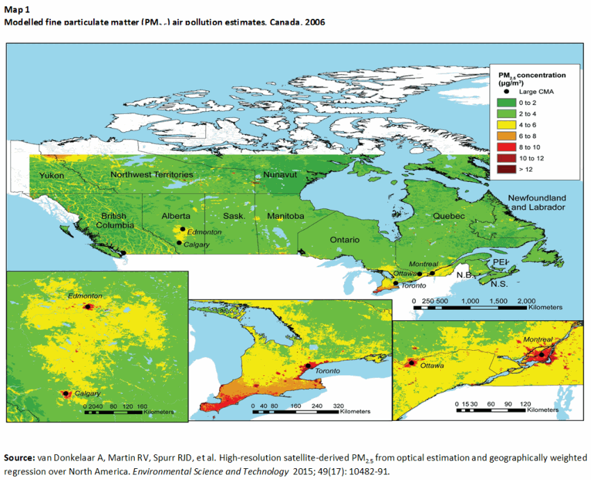
Description for map 1
Map 1 displays national patterns in PM2.5 exposure. The place of residence of non-institutional census respondents was mapped in a Geographic Information Systems (GIS) based on the postal code reported on the Census and Statistics Canada’s Postal Code Conversion File plus, which uses a population-weighted random allocation algorithm to provide a geographical representative point for postal codes. Census respondents were spatially linked in GIS to gridded estimates of PM2.5 at 1 km2 resolution from a published PM2.5 dataset. The dataset was derived from column aerosol optical depth retrievals from the Moderate Resolution Imaging Spectroradiometer (MODIS) and related to near-surface PM2.5 using information from the GEOS-Chem chemical transport model. Geographically weighted regression was applied to produce a surface layer of yearly average PM2.5 at an approximately 1 km2 resolution. Estimates of mean (± standard deviation) PM2.5 exposure were derived for the total population, and for urban core, urban fringe and rural populations.
In most of Canada, PM2.5 concentrations in 2006 were less than 4 μg/m3. PM2.5 exposure estimates were very high in parts of southern Ontario (particularly around Toronto and Windsor), and in major cities. In urban fringe areas, concentrations were in the 4 to 6 μg/m3 range. Urban cores estimates, notably, in southern Ontario, Ottawa-Montreal, and Edmonton-Calgary, reached 8 μg/m3.
- Date modified: