Common menu bar links
2007
Archived Content
Information identified as archived is provided for reference, research or recordkeeping purposes. It is not subject to the Government of Canada Web Standards and has not been altered or updated since it was archived. Please "contact us" to request a format other than those available.
Major drainage area and sub-drainage area geography
Hydrologists identify eleven major drainage areas in Canada and 164 sub-drainage areas. The complete drainage area framework can be obtained from Natural Resources Canada. Descriptions of each of the drainage areas follow.
Major drainage area descriptions
The Maritime Provinces drainage area covers New Brunswick, Prince Edward Island, Nova Scotia and part of the Gaspé Peninsula in eastern Quebec. This area drains into the Gulf of St. Lawrence and the Atlantic Ocean. Halifax, Fredericton and Charlottetown are located in this drainage area.
The St. Lawrence drainage area includes all of southern Quebec, southern Ontario and Newfoundland. Cities in this drainage area include Montreal,Toronto, Ottawa and Thunder Bay in Ontario and St. John’s and Corner Brook in Newfoundland.
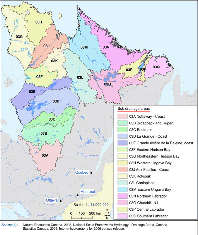
The Northern Quebec and Labrador drainage area covers all the area just north of the St. Lawrence drainage area. Most of the water in this drainage area drains into Hudson, James and Ungava bays. The Labrador portion of the drainage area drains directly into the Atlantic Ocean. Communities in this drainage area include Chibougamau and Kuujjuaq in Quebec and HappyValley–GooseBay in Labrador.
The Southwestern Hudson Bay drainage area covers a large portion of northern Ontario, a small part of western Quebec and northeastern Manitoba. Communities in this drainage area include Val-d’Or in Quebec and Kapuskasing and Timmins in Ontario.
The Nelson River drainage area covers most of the southern Prairie provinces, from the Rockies to northwestern Ontario. Major cities within this drainage are Winnipeg, Regina, Saskatoon, Calgary and Edmonton. Water from the Nelson River drainage area ultimately drains into Hudson Bay.
The Western and Northern Hudson Bay drainage area includes parts of eastern Alberta, all of the middle portions of Saskatchewan, northeastern Manitoba, the northeastern portion of the Northwest Territories, southeastern Nunavut, the Hudson Bay islands and part of Baffin Island. The following communities are found in this drainage area: Bonnyville, Alberta; La Ronge, Saskatchewan; and Rankin Inlet, Nunavut.
The Great Slave Lake drainage area is composed of northern Alberta, northern Saskatchewan, southern Northwest Territories and a small portion of British Columbia. Cities within this watershed are Grande Prairie and High Level in Alberta, Yellowknife and Hay River in the Northwest Territories, and Fort St. John in British Columbia.
The Pacific drainage area includes all the area that is west of the continental divide, representing about 70% of the province of British Columbia. The southwestern part of the Yukon is also part of this drainage area. Some of the communities in the eastern portion of the drainage area are Kimberley, Golden and Invermere, all in British Columbia. Cities in the western portion include Vancouver, Victoria, Abbotsford and Whistler. Terrace and Prince Rupert in British Columbia are among the northern communities in this drainage area.
The Yukon River drainage area contains most of the western portion of the Yukon territory. The most southerly portion of this drainage area is in British Columbia. Communities and cities in this drainage area are Whitehorse, Dawson and Old Crow in the Yukon. The Yukon River flows through central Alaska, and ultimately into the Bering Sea.
The Arctic drainage area, the largest of all drainage areas in Canada, covers most of the arctic islands and large portions of the Northwest Territories, Nunavut, the Yukon Territory and, to a lesser extent, British Columbia and Alberta. Communities within this drainage area include Inuvik in the Northwest Territories, Fort Nelson in British Columbia, and Pangnirtung, Iqualuit and ResoluteBay in Nunavut.
Finally, the Mississippi drainage area covers a small area in the southernmost parts of Alberta and Saskatchewan.


