
Chart 2.4
Forest type by ecozone, 2006
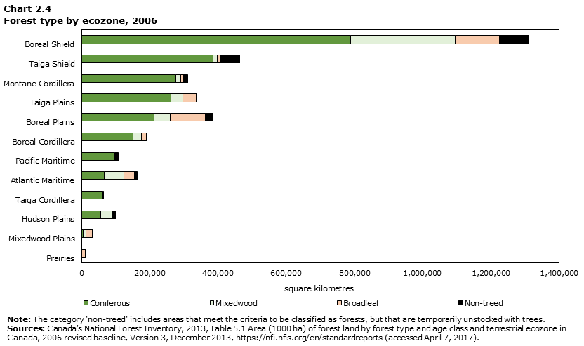
Data table for Chart 2.4
| Ecozone | Coniferous | Broadleaf | Mixedwood | Non-treed | Forest land |
|---|---|---|---|---|---|
| square kilometres | |||||
| Boreal Shield | 788,790 | 129,030 | 307,893 | 87,035 | 1,312,747 |
| Taiga Shield | 384,541 | 9,067 | 13,715 | 55,607 | 462,929 |
| Montane Cordillera | 276,268 | 7,547 | 15,176 | 12,292 | 311,285 |
| Taiga Plains | 262,123 | 37,659 | 35,563 | 667 | 336,012 |
| Boreal Plains | 212,335 | 103,706 | 47,458 | 21,048 | 384,546 |
| Boreal Cordillera | 150,186 | 13,700 | 25,875 | 1,403 | 191,165 |
| Pacific Maritime | 94,765 | 2,815 | 2,682 | 7,179 | 107,441 |
| Atlantic Maritime | 67,353 | 30,918 | 56,325 | 8,361 | 162,957 |
| Taiga Cordillera | 59,426 | 1,520 | 3,483 | 0 | 64,429 |
| Hudson Plains | 55,427 | 965 | 33,112 | 9,074 | 98,577 |
| Mixedwood Plains | 4,252 | 17,720 | 8,875 | 845 | 31,692 |
| Prairies | 435 | 11,096 | 145 | 302 | 11,978 |
|
Note: The category 'non-treed' includes areas that meet the criteria to be classified as forests, but that are temporarily unstocked with trees. Source: Canada's National Forest Inventory, 2013, Table 5.1 Area (1000 ha) of forest land by forest type and age class and terrestrial ecozone in Canada, 2006 revised baseline, Version 3, December 2013, https://nfi.nfis.org/en/standardreports (accessed April 7, 2017). |
|||||
- Date modified: