
Chart 2.1
Forest and non-forest area, 2006
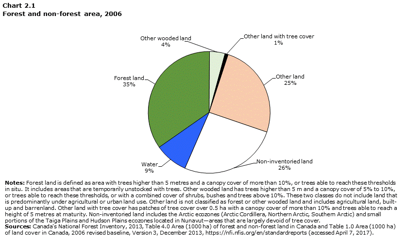
Data table for Chart 2.1
| Forest land | Other wooded land | Other land with tree cover | Other land | Non-inventoried land | Water | Total | |
|---|---|---|---|---|---|---|---|
| square kilometres | |||||||
| Area (km2) | 3,475,758 | 408,657 | 84,989 | 2,514,132 | 2,621,899 | 874,251 | 9,979,685 |
| As % of Canada total area | 35 | 4 | 1 | 25 | 26 | 9 | 100 |
|
Notes: Forest land is defined as area with trees higher than 5 metres and a canopy cover of more than 10%, or trees able to reach these thresholds in situ. It includes areas that are temporarily unstocked with trees. Other wooded land has trees higher than 5 m and a canopy cover of 5% to 10%, or trees able to reach these thresholds, or with a combined cover of shrubs, bushes and trees above 10%. These two classes do not include land that is predominantly under agricultural or urban land use. Other land is not classified as forest or other wooded land and includes agricultural land, built-up and barrenland. Other land with tree cover has patches of tree cover over 0.5 ha with a canopy cover of more than 10% and trees able to reach a height of 5 metres at maturity. Non-inventoried land includes the Arctic ecozones (Arctic Cordillera, Northern Arctic, Southern Arctic) and small portions of the Taiga Plains and Hudson Plains ecozones located in Nunavut—areas that are largely devoid of tree cover. Sources: Canada's National Forest Inventory, 2013, Table 4.0 Area (1000 ha) of forest and non-forest land in Canada and Table 1.0 Area (1000 ha) of land cover in Canada, 2006 revised baseline, Version 3, December 2013, https://nfi.nfis.org/en/standardreports (accessed April 7, 2017). |
|||||||
- Date modified: