
Chart 2.3
Annual water yield, Pacific Ocean drainage area, 1971 to 2013
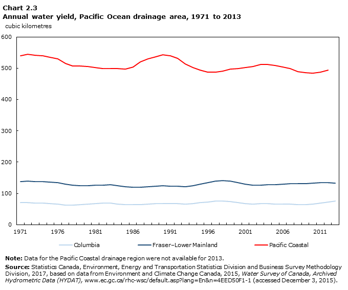
Data table for Chart 2.3
| Fraser–Lower Mainland | Columbia | Pacific Coastal | |
|---|---|---|---|
| cubic kilometres | |||
| 1971 | 137.6 | 70.7 | 540.1 |
| 1972 | 138.6 | 70.2 | 544.7 |
| 1973 | 137.4 | 69.0 | 541.9 |
| 1974 | 137.7 | 68.7 | 540.4 |
| 1975 | 135.9 | 66.6 | 534.2 |
| 1976 | 134.0 | 65.6 | 529.5 |
| 1977 | 128.9 | 63.2 | 515.1 |
| 1978 | 125.8 | 63.3 | 507.4 |
| 1979 | 124.1 | 64.1 | 507.1 |
| 1980 | 124.0 | 65.6 | 506.1 |
| 1981 | 125.4 | 67.6 | 502.6 |
| 1982 | 126.6 | 68.7 | 498.6 |
| 1983 | 127.0 | 68.6 | 499.5 |
| 1984 | 124.9 | 66.3 | 498.3 |
| 1985 | 121.7 | 64.6 | 497.7 |
| 1986 | 120.1 | 63.9 | 504.3 |
| 1987 | 119.7 | 64.0 | 519.8 |
| 1988 | 120.5 | 65.3 | 530.7 |
| 1989 | 122.4 | 66.9 | 536.1 |
| 1990 | 124.0 | 67.9 | 542.3 |
| 1991 | 123.0 | 67.4 | 539.8 |
| 1992 | 122.8 | 66.8 | 531.0 |
| 1993 | 121.9 | 66.4 | 513.9 |
| 1994 | 124.0 | 67.6 | 502.0 |
| 1995 | 130.0 | 71.2 | 494.1 |
| 1996 | 133.8 | 73.0 | 487.2 |
| 1997 | 139.0 | 75.0 | 487.4 |
| 1998 | 140.4 | 75.2 | 490.5 |
| 1999 | 139.0 | 73.4 | 496.7 |
| 2000 | 134.8 | 70.4 | 498.8 |
| 2001 | 130.1 | 67.9 | 502.3 |
| 2002 | 126.5 | 66.4 | 505.0 |
| 2003 | 126.5 | 66.7 | 511.2 |
| 2004 | 128.0 | 67.5 | 512.0 |
| 2005 | 127.4 | 66.3 | 508.8 |
| 2006 | 129.4 | 66.0 | 504.0 |
| 2007 | 131.6 | 65.0 | 498.5 |
| 2008 | 130.8 | 63.9 | 489.5 |
| 2009 | 131.8 | 64.5 | 485.8 |
| 2010 | 132.2 | 66.3 | 483.4 |
| 2011 | 134.1 | 69.5 | 487.9 |
| 2012 | 135.2 | 73.0 | 493.8 |
| 2013 | 133.2 | 75.9 | Note ..: not available for a specific reference period |
|
.. not available for a specific reference period Note: Data for the Pacific Coastal drainage region were not available for 2013. Source: Statistics Canada, Environment, Energy and Transportation Statistics Division and Business Survey Methodology Division, 2017, based on data from Environment and Climate Change Canada, 2015, Water Survey of Canada, Archived Hydrometric Data (HYDAT), (accessed December 3, 2015). |
|||
- Date modified: