
Environment Fact Sheets
Long-term population density change in Toronto and Vancouver, 1971 to 2016

Archived Content
Information identified as archived is provided for reference, research or recordkeeping purposes. It is not subject to the Government of Canada Web Standards and has not been altered or updated since it was archived. Please "contact us" to request a format other than those available.
by Jennie Wang and Hugo Larocque
Skip to text
Text begins
This new analysis provides comparable time series data for the census metropolitan areas (CMAs) and census subdivisions (CSDs) of Vancouver and Toronto for 1971 and 2016, providing a uniquely long-term view of urbanization in these areas. Urbanization patterns, including densification within existing urban areas and urban expansion on the periphery, influence the supply and value of ecosystem services.
Together, the CMAs of Toronto and Vancouver accounted for 24% of Canada’s population in 2016. The population of these large metropolitan areas has grown significantly over time, affecting the extent and density of residential areas in these cities as they have developed (Map 1 and Map 2).
The overall population of Toronto CMA increased 120% from 2.7 million in 1971 to 5.9 million in 2016, with the largest increases in population seen in the largest cities, including Toronto, Mississauga and Brampton (Table 1). The fastest growth occurred in Vaughan and Markham to the north of Toronto.
The overall population of Vancouver CMA increased 128% from 1.1 million in 1971 to 2.5 million in 2016, with the largest increases in population occurring in the cities of Surrey, Vancouver and Richmond (Table 2). Surrey, Langley and Pitt Meadows, located in the south-east and east of the metropolitan area, were among the fastest growing census subdivisions.
While overall population and population density increased in almost all census subdivisions, this growth was often concentrated in certain areas. For example, in Toronto significant increases in density occurred in the Waterfront Communities and Niagara neighbourhoods, as well as in the Bay Street Corridor and along rapid transit lines towards North York. Similarly, increased density in Vancouver was concentrated in downtown Vancouver and south of False Creek, and also occurred in parts of East Vancouver, Burnaby and New Westminster along rapid transit lines.
At the same time, some established residential neighbourhoods saw little or no change in population density or may have experienced decreases in population. These patterns may reflect the widespread trend of decreasing household size coupled with retention of older single-detached, semi-detached and duplex housing stock in some areas and the construction of higher density multi-dwelling types in others.
Population growth can have different effects on urban form and can lead to redevelopment, infill development and/or the expansion of artificial surfaces and built-up areas on the periphery of cities. For example, a comparison of the population growth areas to previously published maps of built-up area change in Toronto (Map 3.29) and Vancouver (Map 3.31) shows the significant overlap between changes in population density and urban expansion (Statistics Canada, 2016).Note
In addition to city zoning bylaws, which regulate the type of development that occurs in cities, legislation exists in both areas to protect land from development. Ontario’s Greenbelt was established in 2005 to protect greenspace, farmland, wetlands and watersheds in the Golden Horseshoe area, which includes Toronto (Ontario Ministry of Municipal Affairs and Housing [MAH], 2018). The Agricultural Land Reserve was established in British Columbia in 1970s to protect high quality farmland from development (Agricultural Land Commission of British Columbia [ALC], 2014). The Greenbelt and Agricultural Land Reserve areas are included on the maps (MAH, 2017; ALC, 2018).
Description for Map 1
This map includes two main components: a map of population density for Toronto CMA in 1971 and a similar map for 2016. A legend indicates the categories displayed on the map, displays the location of Toronto on a map of Canada, and provides the Toronto CMA total population in 1971 (2,699,927) and 2016 (5,928,040).
Population density categories are indicated by color. Category 1 (dark maroon) represents areas with a population density greater than or equal to 25,000 persons per km2, category 2 (bright maroon) represents areas from 12,500 to less than 25,000 persons per km2, category 3 (fuchsia) represents areas from 5,000 to less than 12,500 persons per km2, category 4 (light fuchsia) represents areas from 2,500 to less than 5,000 persons per km2, category 5 (lilac) represents areas from 1,000 to less than 2,500 persons per km2, category 6 (pale lilac) represents areas from 400 to less than 1,000 persons per km2 and category 7 (white) represents area with less than 400 persons per km2.
Areas outside the CMA boundary are shown in grey. Ontario Greenbelt areas are also indicated on the map with green hatching.
On the map, labels indicate the location of some of the most populous census subdivisions including Toronto, Mississauga, Brampton, Markham, Vaughan, Richmond Hill, Oakville, Ajax, Milton and Newmarket. Water is pale blue.
In Toronto, the extent of populated areas grew significantly in census subdivisions outside the core City of Toronto from 1971 to 2016. This expansion can be seen particularly in Vaughan and Markham to the north, in Brampton to the north-west, Milton to the west and Ajax to the east. In the core area, there was an increase in areas with a population density greater or equal to 25,000 persons per km2 (category 1), for example in the Waterfront Communities, Niagara and Bay Street Corridor neighbourhoods. At the same time, some established residential neighbourhoods in Toronto saw little or no change in population density or may have experienced decreases in population.
| Category | Population density | 1971 | 2016 |
|---|---|---|---|
| number | |||
| Category 1 | ≥ 25,000 persons per km2 | 203 | 568 |
| Category 2 | 12,500 to < 25,000 persons per km2 | 1,266 | 1,195 |
| Category 3 | 5,000 to < 12,500 persons per km2 | 4,048 | 11,850 |
| Category 4 | 2,500 to < 5,000 persons per km2 | 4,271 | 8,763 |
| Category 5 | 1,000 to < 2,500 persons per km2 | 3,056 | 3,330 |
| Category 6 | 400 to < 1,000 persons per km2 | 2,475 | 872 |
| Category 7 | < 400 persons per km2 | 16,658 | 5,399 |
| Note: 1971 enumeration area population data has been downscaled to the 2016 dissemination blocks. | |||
The Greenbelt area is included on the 1971 map for references purposes only.
Note: These maps show dissemination block (DB) population density in 1971 and 2016. The 1971 DB populations were adjusted by proportionately allocating 1971 enumeration area (EA) populations to the 2016 DB geography, based on the 2001 DB to 1971 EA population ratios. While some misallocation of 1971 EA populations to DBs that were non-residential in 1971 likely occurs, the overall impact on the 1971 population density map is expected to be small.
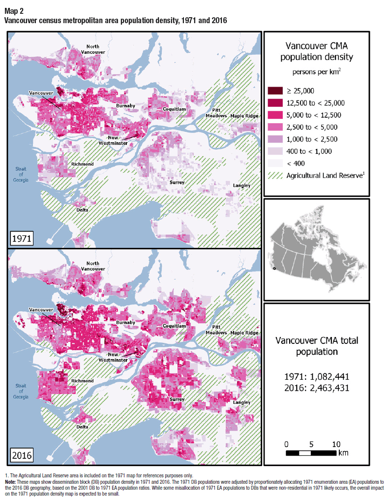
Description for Map 2
This map includes two main components: a map of population density for Vancouver CMA in 1971 and a similar map for 2016. A legend indicates the categories displayed on the map, displays the location of Vancouver on a map of Canada, and provides the Vancouver CMA total population in 1971 (1,082,441) and 2016 (2,463,431).
Population density categories are indicated by color. Category 1 (dark maroon) represents areas with a population density greater than or equal to 25,000 persons per km2, category 2 (bright maroon) represents areas from 12,500 to less than 25,000 persons per km2, category 3 (fuchsia) represents areas from 5,000 to less than 12,500 persons per km2, category 4 (light fuchsia) represents areas from 2,500 to less than 5,000 persons per km2, category 5 (lilac) represents areas from 1,000 to less than 2,500 persons per km2, category 6 (pale lilac) represents areas from 400 to less than 1,000 persons per km2 and category 7 (white) represents area with less than 400 persons per km2.
British Columbia Agricultural Land Reserve areas are also indicated on the map with green hatching.
On the map, labels indicate the location of some of the most populous census subdivisions including Vancouver, Surrey, Burnaby, Richmond, Coquitlam, Langley, Delta, North Vancouver, Maple Ridge and New Westminster. Water is pale blue.
In Vancouver, the extent of populated areas grew significantly in census subdivisions outside the core City of Vancouver from 1971 to 2016. This expansion can be seen particularly south-east and east of the city, for example, in Surrey and Langley, and in Pitt Meadows, Maple Ridge and Coquitlam. There was an increase in areas with a population density in categories 1 and 2, greater or equal to 25,000 persons per km2 and 12,500 to less than 25,000 persons per km2, for example, in Downtown Vancouver, south of False Creek and around Metrotown in Burnaby. At the same time, some established residential neighbourhoods saw little or no change in population density or may have experienced decreases in population.
| Category | Population density | 1971 | 2016 |
|---|---|---|---|
| number | |||
| Category 1 | ≥ 25,000 persons per km2 | 40 | 252 |
| Category 2 | 12,500 to < 25,000 persons per km2 | 252 | 711 |
| Category 3 | 5,000 to < 12,500 persons per km2 | 1,875 | 3,930 |
| Category 4 | 2,500 to < 5,000 persons per km2 | 3,811 | 4,991 |
| Category 5 | 1,000 to < 2,500 persons per km2 | 2,831 | 1,882 |
| Category 6 | 400 to < 1,000 persons per km2 | 2,091 | 552 |
| Category 7 | < 400 persons per km2 | 4,295 | 2,877 |
| Note: 1971 enumeration area population data has been downscaled to the 2016 dissemination blocks. | |||
The Agricultural Land Reserve area is included on the 1971 map for references purposes only.
Note: These maps show dissemination block (DB) population density in 1971 and 2016. The 1971 DB populations were adjusted by proportionately allocating 1971 enumeration area (EA) populations to the 2016 DB geography, based on the 2001 DB to 1971 EA population ratios. While some misallocation of 1971 EA populations to DBs that were non-residential in 1971 likely occurs, the overall impact on the 1971 population density map is expected to be small.
| Geographic name | Type | 2016 | 1971 | 2016 | ||
|---|---|---|---|---|---|---|
| Land area | Population | Private dwelling | Population | Private dwelling | ||
| km2 | number | |||||
| Toronto | CMA | 5,905.8 | 2,699,927 | 794,253 | 5,928,040 | 2,235,145 |
| Toronto | C | 630.2 | 2,089,729 | 630,164 | 2,731,571 | 1,179,057 |
| Mississauga | CY | 292.4 | 172,510 | 46,973 | 721,599 | 248,469 |
| Brampton | CY | 266.4 | 69,943 | 18,252 | 593,638 | 173,428 |
| Markham | CY | 212.3 | 36,684 | 9,557 | 328,966 | 106,131 |
| Vaughan | CY | 273.6 | 15,873 | 4,270 | 306,233 | 96,657 |
| Richmond Hill | T | 101.1 | 32,384 | 8,680 | 195,022 | 66,465 |
| Oakville | T | 138.9 | 59,043 | 16,091 | 193,832 | 68,617 |
| Ajax | T | 67.0 | 17,878 | 4,639 | 119,677 | 38,105 |
| Milton | T | 363.2 | 13,583 | 3,638 | 110,128 | 35,537 |
| Pickering | CY | 231.5 | 25,196 | 6,239 | 91,771 | 31,630 |
| Newmarket | T | 38.5 | 18,941 | 5,059 | 84,224 | 29,315 |
| Caledon | T | 688.2 | 17,422 | 4,689 | 66,502 | 22,021 |
| Halton Hills | T | 276.3 | 31,136 | 8,324 | 61,161 | 21,475 |
| Aurora | T | 49.8 | 13,614 | 3,611 | 55,445 | 19,381 |
| Whitchurch-Stouffville | T | 206.2 | 11,262 | 3,113 | 45,837 | 15,712 |
| Georgina | T | 287.8 | 14,959 | 4,570 | 45,418 | 18,687 |
| Bradford West Gwillimbury | T | 201.0 | 6,673 | 1,803 | 35,325 | 11,918 |
| New Tecumseth | T | 274.2 | 10,438 | 2,944 | 34,242 | 13,191 |
| Orangeville | T | 15.6 | 8,074 | 2,400 | 28,900 | 10,696 |
| King | TP | 333.3 | 12,864 | 3,400 | 24,512 | 8,736 |
| East Gwillimbury | T | 245.0 | 9,359 | 2,427 | 23,991 | 8,279 |
| Uxbridge | TP | 420.9 | 9,507 | 2,619 | 21,176 | 7,946 |
| Mono | T | 277.8 | 2,735 | 757 | 8,609 | 3,127 |
| Chippewas of Georgina Island First Nation | IRI | 14.5 | 120 | 34 | 261 | 565 |
| Note: The 1971 population and dwelling data have been aggregated to the 2016 Census boundaries based on the location of the EA polygons and their representative points. For this reason, some 1971 population and dwelling totals do not match previously released tabulations. | ||||||
| Geographic name | Type | 2016 | 1971 | 2016 | ||
|---|---|---|---|---|---|---|
| Land area | Population | Private dwelling | Population | Private dwelling | ||
| km2 | number | |||||
| Vancouver | CMA | 2,882.7 | 1,082,441 | 345,897 | 2,463,431 | 1,027,613 |
| Vancouver | CY | 115.0 | 426,055 | 153,193 | 631,486 | 309,418 |
| Surrey | CY | 316.4 | 98,601 | 26,954 | 517,887 | 181,159 |
| Burnaby | CY | 90.6 | 125,660 | 38,657 | 232,755 | 98,030 |
| Richmond | CY | 129.3 | 62,121 | 16,945 | 198,309 | 77,478 |
| Coquitlam | CY | 122.3 | 53,230 | 13,332 | 139,284 | 54,393 |
| Langley | DM | 308.0 | 21,936 | 6,360 | 117,285 | 43,720 |
| Delta | DM | 180.2 | 45,860 | 12,062 | 102,238 | 37,590 |
| North Vancouver | DM | 160.8 | 57,861 | 15,603 | 85,935 | 32,624 |
| Maple Ridge | CY | 266.8 | 24,476 | 7,423 | 82,256 | 31,400 |
| New Westminster | CY | 15.6 | 42,835 | 15,448 | 70,996 | 34,235 |
| Port Coquitlam | CY | 29.2 | 19,560 | 5,221 | 58,612 | 22,586 |
| North Vancouver | CY | 11.8 | 31,847 | 11,519 | 52,898 | 26,426 |
| West Vancouver | DM | 87.3 | 35,452 | 11,246 | 42,473 | 18,649 |
| Port Moody | CY | 25.9 | 10,778 | 2,938 | 33,551 | 13,318 |
| Langley | CY | 10.2 | 4,684 | 1,508 | 25,888 | 12,264 |
| White Rock | CY | 5.1 | 10,349 | 4,127 | 19,952 | 10,856 |
| Pitt Meadows | CY | 86.5 | 2,837 | 773 | 18,573 | 7,356 |
| Greater Vancouver A | RDA | 816.3 | 3,643 | 1,088 | 16,133 | 8,542 |
| Bowen Island | IM | 50.1 | 350 | 167 | 3,680 | 1,915 |
| Capilano 5 | IRI | 1.7 | 1,332 | 578 | 2,931 | 1,433 |
| AnmoreTable 2 Note 1 | VL | 27.5 | 906 | 272 | 2,210 | 723 |
| Burrard Inlet 3 | IRI | 1.1 | 152 | 27 | 1,855 | 932 |
| Musqueam 2 | IRI | 1.8 | 650 | 129 | 1,652 | 615 |
| Lions Bay | VL | 2.5 | 396 | 121 | 1,334 | 547 |
| Tsawwassen | IRI | 6.6 | 81 | 22 | 816 | 368 |
| BelcarraTable 2 Note 1 | VL | 5.5 | 0 | 0 | 643 | 292 |
| Mission 1 | IRI | 0.3 | 471 | 103 | 576 | 178 |
| Matsqui 4Table 2 Note 2 | IRI | 0.3 | 0 | 0 | 471 | 286 |
| Katzie 1 | IRI | 0.4 | 91 | 18 | 262 | 83 |
| Seymour Creek 2Table 2 Note 2 | IRI | 0.5 | 0 | 0 | 123 | 40 |
| Semiahmoo | IRI | 1.3 | 119 | 41 | 120 | 64 |
| McMillan Island 6 | IRI | 1.8 | 83 | 17 | 94 | 32 |
| Coquitlam 1Table 2 Note 3 | IRI | 0.0 | 6 | 2 | 54 | 25 |
| Barnston Island 3 | IRI | 0.6 | 0 | 0 | 49 | 16 |
| Katzie 2 | IRI | 0.3 | 0 | 0 | 40 | 15 |
| Musqueam 4 | IRI | 0.5 | 0 | 0 | 10 | 4 |
| Coquitlam 2 | IRI | 0.8 | 19 | 3 | 0 | 0 |
| Langley 5 | IRI | 1.3 | 0 | 0 | 0 | 0 |
| Whonnock 1 | IRI | 0.4 | 0 | 0 | 0 | 1 |
|
||||||
Note to readers
These new thematic maps show population density at the dissemination block level within the CMAs of Toronto and Vancouver for 1971 and 2016 (Statistics Canada, 2017a,b,c). The 1971 maps were made possible following the restoration and digitization of collapsed 1971 Census of Population enumeration area polygons for CMAs, using original paper or microform census maps.
An enumeration area (EA) refers to the spatial unit canvassed by one Census Representative and could include up to 300 households, depending on its location. Population and dwelling data are linked to a representative EA point. The point’s location generally indicates the population centre of the respective enumeration area (Statistics Canada, 1972).
In Maps 1 and 2, the 1971 EA point population data was downscaled to the finer scale dissemination block (DB) geography that was introduced in 2001. The 1971 EA population data were allocated proportionately to DBs based on the 2001 DB to 1971 EA population ratios (Statistics Canada, 2002a,b). Population density is calculated as the DB population divided by the land area. While some misallocation of 1971 EA populations to DBs likely occurs (e.g., DB that that were non-residential in 1971 but that were subsequently developed for residential area), the overall impact on the 1971 population density maps is expected to be small.
In Tables 1 and 2, the 1971 population and dwelling data associated with EAs is aggregated according to the 2016 Census of Population census subdivision (CSD) and CMA boundaries. For this reason, some 1971 totals do not match previously released tabulations. In the CMA of Toronto, these differences relate to changing CSD boundaries including in Brampton, Mississauga, Caledon, Oakville, Milton and Halton Hills to the west of the region, as well as in Toronto, Ajax and Pickering to the east and in New Tecumseth to the north. In Vancouver CMA, these differences relate to changing boundaries of Pitt Meadows, Capilano 5, Musqueam 2, Greater Vancouver A, Anmore and Belcarra.
References
Agricultural Land Commission of British Columbia [ALC], 2018, ALR Zones shapefile, dated July 31, 2018.
Agricultural Land Commission of British Columbia [ALC], 2014, ALR History.
Ontario Ministry of Municipal Affairs and Housing [MAH], 2018, Greenbelt Protection .
Ontario Ministry of Municipal Affairs and Housing [MAH], 2017, Greenbelt outer boundary, dated July 1, 2017.
Statistics Canada, 2017a, “Restoration of the 1971 enumeration area polygons for Canada’s largest cities,” Environmental Statistics: Boundary Files, Catalogue no. 16-510-X.
Statistics Canada, 2017b, Geosuite 2016, Catalogue no. 92-150-X.
Statistics Canada, 2017c, 2016 Census - Boundary Files, Catalogue no. 92-160-X.
Statistics Canada, 2016, “The changing landscape of census metropolitan areas,” Human Activity and the Environment, Catalogue no. 16-201-X.
Statistics Canada, 2002a, Geosuite 2001, Catalogue no. 92F0150GIE.
Statistics Canada, 2002b, 2001 Census – Boundary files, Catalogue no. 92F0171GIE.
Statistics Canada, 1972, Dictionary of the 1971 Census Terms, Catalogue no. 12-540.
- Date modified: